SCAVIHO – Scalable Vegetation Index and Harvesting Forecaster
Winning project from the 1st Open Call funded by the AI4Copernicus Project
Companies: ENCORE LAB / MAETIERRA IAE
Countries: Spain | Domain: Agriculture
An interview with the winners – Diego Polo, representing the SCAVIHO project
Q: What was your motivation for creating this proposal?
A: Satellite images are used by farmer for long time ago, although new indexes are developed for specific tasks with great precision the NDVI index one of the well-known and easy to understand by farmers have a major drawback: interpretability during main stages of the season where index does not range between extreme values. We aim to provide new insight to this index thanks to basic image transformations and correlating it with phenological status. Also, with these data the project is able to forecast harvesting dates.
Q: Which is the most critical impact (societal or other) that your project could make (if you could name one) ?
A: Outputs of the project are easy to interpret without any required extra knowledge about NDVI index what allows an easy adaptation. Also swapping between different scales is affordable for visualisation software with minimum computational cost. The calculation of harvesting dates, although is not new, requires great effort from the farmer to register phenological statuses of crops and to develop model, many times out of the scope of many agricultural business model. But thanks to already calculated PI curves and available NDVI images on Copernicus cloud a farmer can have reliable results about harvesting and planification of agricultural labours. This approach is affordable as no need to develop custom models for every farmer. Also the project tackle some social problems: increase of rentability of agriculture activity, increasing investment in rural areas, keeping jobs in rural areas, technification of agriculture.
Q: Considering the recent funding received through the AI4Copernicus Open Calls, do you have any plans for further development of your idea?
A: Companies in the consortium already uses satellite images for daily operations. MAETIERRA as a winery to control their plots and ENCORE LAB as a technological solution provider for agriculture includes NDVI maps in his software. The project will boost the usage of this technology among the partners
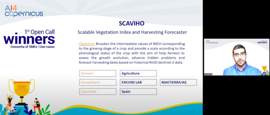
Abstract of the project: Normalised Difference Vegetation Index (NDVI) is widely used in precision agriculture due to versatility and reliability in reporting general crop’s canopy status and is used during all the season. NDVI values range from 0 to 1, and although extreme values are well interpreted by farmers as a sign of problems in the crop (lack or excess of water or nutrients), intermediate values during the growing stage are not used due to its difficulty of interpretation although they can disclose important information about growing evolution of the crop. The main objective of the project is to broaden the intermediate values of NDVI corresponding to the growing stage of a crop and to provide a scale according to the phenological status of the crop with the aim of help farmers to assess the growth evolution, to advance hidden problems and to forecast harvesting dates based on historical NVDI Sentinel-2 data.